Reading Davies and Kent’s Red Atlas for the Telegraph, 13 January 2018
This is a journey through an exotic world conjured into being by the Military Topographic Directorate of the General Staff of the Soviet Army. Tasked by Stalin during the Second World War to accurately and secretly map the Soviet Union, its Eastern European allies, its Western adversaries, and the rest of the world, the Directorate embarked on the largest mapping effort in history, Too many maps have been lost for us to be entirely sure what coverage was attained, but it must have been massive. Considering the UK alone, if there are detailed street plans of the market town of Gainsborough in Lincolnshire, we can be reasonably sure there were once maps of Carlisle and Hull.
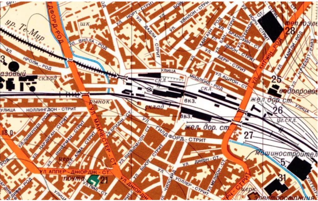
From internal evidence (serial numbers and such-like) we know there were well in excess of 1 million maps produced. Only a few survive today, and the best preserved of them, the most beautiful, the most peculiar, the most chilling, are reproduced here. The accompanying text, by cartographers John Davies and Alexander Kent, is rich in detail, and it needs to be. Soviet intelligence maps boast a level of detail that puts our own handsome Ordnance Survey to shame — a point the authors demonstrate by putting OS maps alongside their Soviet counterparts. You can not only see my road from one of these Soviet maps: you can see how tall the surrounding buildings are. You can read the height of a nearby bridge above water, its dimensions, its load capacity, and what it is made of. As for the river, I now know its width, its flow, its depth, and whether it has a viscous bed (it hasn’t).
This is not a violent tale. There is little evidence that the mapmakers had invasion on their mind. What would have been the point? By the time Russian tanks were rolling down the A14 (Cambridge, UK, 1:10,000 City Plan of 1998), nuclear exchanges would have obliterated most of these exquisite details, carefully garnered from aerial reconnaissance, archival research, Zenit satellite footage and, yes, wonderfully, non-descript men dawdling outside factory gates and police stations. Maybe the maps were for them and their successors. Placenames are rendered phonetically: HEJSTYNZ for Hastings and “ISBON” for Eastbourne on one Polish map. This would have been useful if you were asking directions, but useless if you were in a tank speeding through hostile territory, trying to read the road signs. The Directorate’s city maps came with guides. Some of the details recorded here are sinister enough: Cambridgeshire clay “becomes waterlogged and severely impedes off-road movement of mechanized transport.” Its high hedges “significantly impede observation of the countryside”. But what are we to make of the same guide’s wistful description of the city itself? “The bank of the river Cam is lined with ivy-clad buildings of the colleges of the university, with ridged roofs and turrets… The lodging-houses with their lecture-halls are reminiscent of monasteries or ancient castles.”
Though deployed on an industrial scale, the Soviet mapmakers were artisans, who tried very hard to understand a world they would never have any opportunity to see. They did a tremendous job: why else would their maps have informed the US invasion of Afghanistan, water resource management in Armenia, or oil exploration in India? Now and again their cultural assumptions led them down strange paths. Ecclesiastical buildings lost all significance in the Republic of Ireland, whose landscape became dotted with disused watermills. In England, Beeching’s cull of the railways was incomprehensible to Russian mapmakers, for whom railways were engines of revolution. A 1971 map of Leeds sheet not only shows lines closed in the 1960s; it also depicts and names the Wellington terminus station, adjacent to City station, which had closed in 1938.
The story of the Soviets’ mapping and remapping, particularly of the UK, is an eerie one, and though their effort seems impossibly Heath-Robinson now, the reader is never tempted into complacency. Cartography remains an ambiguous art. For evidence, go to Google Maps and type in “Burghfield”. It’s a village near Reading, home to a decommissioned research station of the Atomic Weapons Establishment. Interestingly, the authors claim that though the site is visible in detail through Google Earth, for some reason Google Maps has left the site blank and unlabelled.
This claim is only partly true. The label is there, though it appears at only the smallest available scale of the map. Add the word “atomic” to your search string, and you are taken to an image that, if not particularly informative, is still adequate for a visit.
Two thoughts followed hard on this non-discovery of mine. First, that I should let this go: my idea of “adequate” mapping is likely to be a lot less rigorous than the authors’; anyway it is more than possible that this corner of Google Maps has been updated since the book went to press. Second, that my idle fact-checking placed me in a new world — or at any rate, one barely out of its adolescence. (Keyhole, the company responsible for what became Google Earth, was founded in 2001.)
Today anyone with a broadband connection can drill down to information once considered the prerogative of government analysts. Visit Google Earth’s Russia, and you can find traces of the forest belts planted as part of Stalin’s Great Transformation of Nature in 1948. You can see how industrial combines worked their way up the Volga, building hydroelectric plants that drowned an area the size of France with unplanned swamps. There’s some chauvinistic glee to be had from this, but in truth, intelligence has become simply another digital commodity: stuff to be mined, filleted, mashed up, repackaged. Open-source intelligence: OSINT. There are conferences about it. Workshops. Artworks.
The Red Atlas is not about endings. It is about beginnings. The Cold War, far from being over, has simply subsumed our civic life. Everyone is in the intelligence business now.